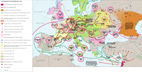
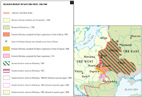
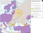
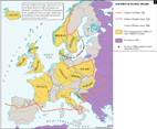
Click on any map to see it enlarged.
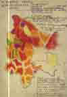
Examples of maps that I have both compiled and drawn: next
 |
 |
 |
 |
|
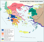
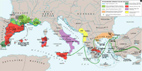
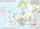
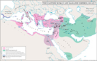
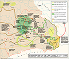
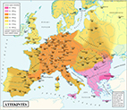
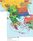
A1 - Power Restructured, 301 BC-202 BC |
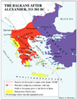
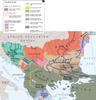
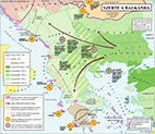
A2 - The Balkans after Alexander, to 301 BC |
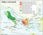
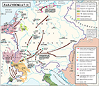
A3
- Epirus and Rome |
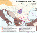
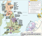
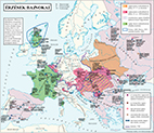
A4 - Developments, 301 BC-33 BC |
 |
 |
 |
 |
|
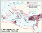
A5
- Christianity at the Early 4th Century |
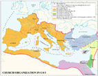
A6
- Church Organisation in C4-5 |
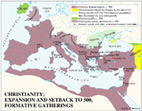
A7 - Christianity; Expansion and Setback to 500, Formative Gatherings |
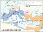
A8
- Arian Kingdoms in 500 |
 |
 |
 |
 |
|
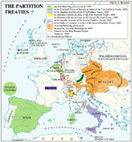
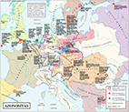
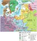
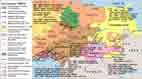
A9 - The Partition Treaties |
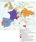
A10 - The Spanish War of Succession |
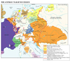
A11 - The Austrian War of Succession |
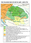
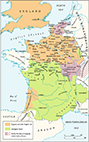
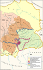
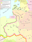
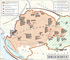
A12 - The Habsburgs in Hungary, 1699-1751 |
 |
 |
 |
 |
|
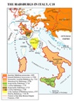
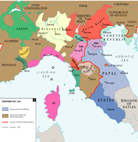
A13
- The Habsburgs in Italy, C18
|
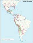
A14
- Discovery and Conquest
|
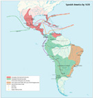
A15
- Spanish America by 1620
|
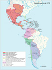
A16
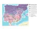
- Spanish America by 1779
|
|
|
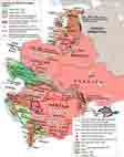
|
|
|
 |
 |
 |
|
|
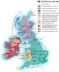
A17-
In Search of Unity, c.650-850
|
A18
- Vikings of the British Isles
|
A19
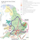
- Wars with the Danes, 980-1016
|
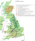
A20-
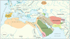
William the Conqueror
|
|
|
|||
 |
 |
 |
 |
|
A21-
England under Stephen
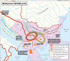
|
A22-Henry
II and his Sons, 1169-1180
|
A23-
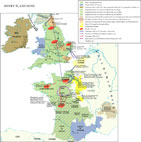
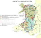
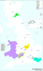
Edward I’s Campaigns in Wales
|
A24-
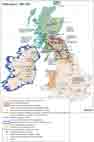
The British Isles at Robert Bruce’s time
|
 |
 |
 |
 |
|
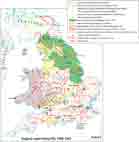
A25-
Scotland under The Stewarts
|
A26-
England under Henry VIII
|
A27-
England and the World around Elizabeth I’s Time
|
A28-
England’s Affairs under Elizabeth I
|
 |
 |
 |
 |
|
A29-
The Civil War during Charles I’s rule
|
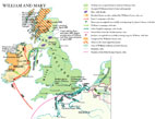
A30-
The British Isles at the time of William and Mary, 1689-1696
|
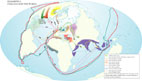
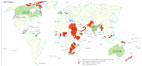
A31-
The British Empire under Victoria
|
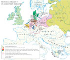
A32-
Victoria’s Family on European Thrones
|
 |
 |
 |
 |
|
A33 -
The British Empire under George V
|
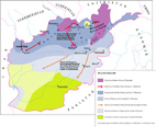
A34-
War against the Taleban
|
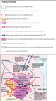
A35-
War in Chechnya
|
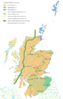
A36-
Linguistic change in Scotland
|
 |
 |
 |
 |
|
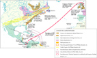
A37-Scotland’s
Atlantic adventures
|
A38-
Byzantine Empire 1081-1204
|
A39-
Byzantine Empire 1261-1341
|
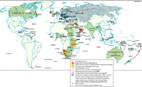
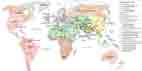
A40-
The World in 700
|
 |
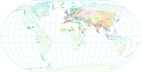 |
 |
 |
|
A41-
The World in 1000
|
A42-
The World in1300
|
A43-
The World in 1500
|
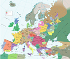
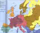
A44-
Europe, 1328
|
 |
 |
 |
 |
|
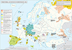
A45-
Europe, 1885
|
A46-
Catalan expansion
|
A47-
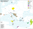
Northern Italy, 1336
|
A48-
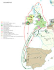
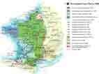
The Reconquista
|
 |
 |
 |
 |
|
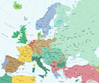
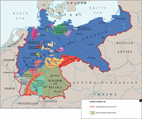
A49-
Imperial Germany, 1871
|
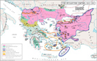
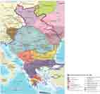
A50-
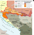
The Balkans, 1878-1908
|
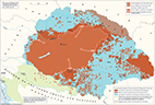
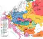
A51-
The dissolution of the Military Frontier
|
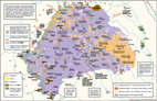
A52-
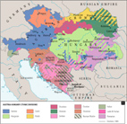
Ethnic division of Austria-Hungary
|
 |
 |
 |
 |
|
A53-
Medieval heresies
|
A54-
The Tatars in Europe
|
A55-
The Jews to the end of C19
|
A56-
Territorial rivalry of East and West
|
 |
 |
 |
 |
|
A57-
Religious rivalry of East and West
|
A58-
Continuity in the East, 1000-2000
|
A59-
Continuity in the West, 1000-2000
|
A60-
European minorities
|
 |
 |
 |
 |
|
A61-
Autonomies
|
A62-
Hungarians in Romania
|
A63-
Trianon treaty
|
A64-
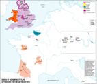
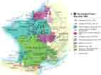
France, 1428
|
 |
 |
 |
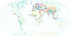
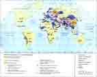
 |
|
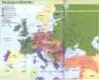
A65-
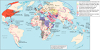
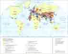
World in conflict
|
A66-
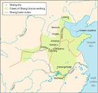
Shang China
|
A67-
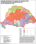
Hungary/ethnicity, 1847
|
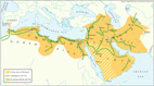
A68-
Eastern Romans and Sassanids
|
 |
 |
 |
 |
|
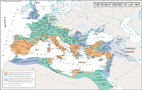
A69-
Roman Empire to A.D. 180
|
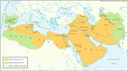
A70-
Muslim world, 700
|
A71-
Muslim world, 700–850
|
A72-
Muslim world, 1000
|
|
|
 |
 |
 |
|
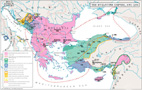
A73-
Ethnicity, mid-C13
|
A74-
Ethnicity, mid-C16
|
A75-
Ethnicity, end of C18
|
A76-
Ethnicity, early C20
|
 |
 |
 |
 |
|
A77-
Peasant uprising
|
A78-
Shakespeare’s Britain scenes
|
A79-
Shakespeare’s mixed scenes
|
A80-
Shakespeare’s not Britain scenes
|
 |
 |
 |
 |
|
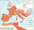
A81-
Neo-Latin languages
|
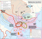
A82-
Romanian dawns
|
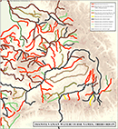
A83-
Watercourse names
|
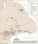
A84-
Settling Romanians
|
 |
|||
|
A85-
Courland in Russia
|
Examples of maps from my published historical atlases: top, next
|
|
 |
 |
|
|
B2
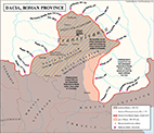
- Roman province
|
B3-
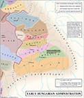
Early administration
|
B4-
Formation of Szekelyland
|
|
 |
 |
 |
 |
|
B5-
Romanian origins
|
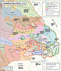
B6-Administration C14
|
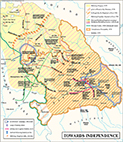
B7-
Towards Independence
|
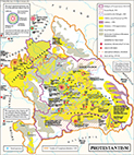
B8-
Protestantism
|
 |
 |
 |
 |
|
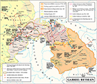
B9-
Gabriel Bethlen
|
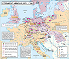
B10-
Studying abroad 1521-1700
|
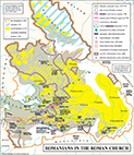
B11-
Romanians in Roman Church
|
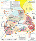
B12-
Events
|
 |
 |
 |
 |
|
B13-
Learning
|
B14-
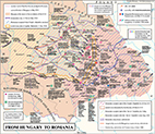
From Hungary to Romania
|
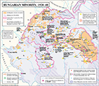
B15-
Hungarian Minority 1920-40
|
B16-
Communism
|
|
|
 |
 |
 |
|
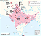
B17- Formation
|
B19-
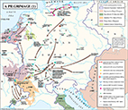
A Pilgrimage
|
B20-
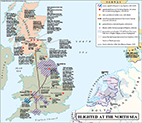
Blighted at the N. Sea
|
|
 |
 |
 |
 |
|
B21-
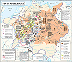
Sent underground
|
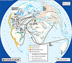
B22-Beyond Europe
|
B23-
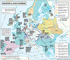
Fighting for others
|
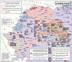
B24-
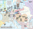
Identity concluded
|
 |
 |
 |
 |
|
B25-
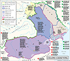
Chains loosening
|
B26-
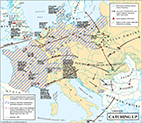
Catching up
|
B27-
From bad to worse
|
B28-
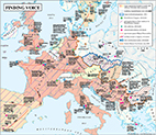
Finding voice
|
|
|
 |
 |
 |
|
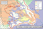
B30 - Saxons’ settling |
B31
- Romanian immigration
|
B32
- Internal upheavals
|
|
|
|
 |
 |
 |
|
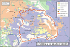
B34 - Onto the wider Balkans |
B35
- A pilgrimage 1 |
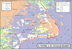
B36
- Blighted at the North Sea
|
|
 |
 |
 |
 |
|
B37 - Gap no more |
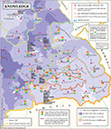
B38 - Identity concluded |
B39 - Overview |
B40
- Spreading joy
|
These maps were not meant to be finished. They are examples of my compilations and instructions to serve as a base for the styled artwork of others: top, next, previous
 |
 |
 |
 |
|
C1
- The World in 1750 |
C2
- Sino - Tibetan State Foundations C7 - middle of C11 |
C3
- Sino-Tibetan conquest of South-East Asia C11 - C18 |
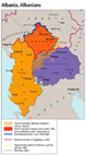
C4
- Albania, Albanians |
 |
 |
 |
 |
|
C5
- The Hittites
|
C6
- Ethnic Minorities, Territorial Autonomies, 1945-85
|
C7
- New states in Eastern Europe, 12-15C
|
C8
- Peasant uprisings in Eastern Europe, 16-18C
|
 |
|||
|
C9
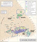
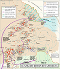
- Ethnic composition of the Mohacs district
|
Examples of published maps that were completed by others based on my compilation and instruction: top, next, previous
 |
 |
 |
 |
|
D1
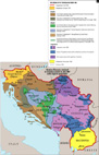
- The Break-up of Yugoslavia |
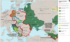
D2
- Central and Eastern Europe 1990 - 2001 |
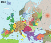
D3
- Europe 1180 |
D4
- Balkans 1360
|
 |
 |
 |
 |
|
D5
- East-Central Europe C13 - C15
|
D6
- British Isles C13-14
|
D7
- The Baltic C12-14
|
D8
- The Reconquista
|
 |
 |
 |
 |
|
D9-The
Hundred Years War to 1400
|
D10
- The Hundred Years War after 1400
|
D11
- The World in the Middle Ages
|
D12
- The World on the eve of European expansion
|
 |
 |
 |
 |
|
D13
- Spread of Christianity, 750-1054
|
D14
- Russia, 1645-76
|
D15
- The Causes of WWI
|
D16
- The Caucaus, 1988-96
|
 |
 |
 |
 |
|
D17
- World religions from 1900
|
D18
- The Collapse of the Central Powers, 1918
|
D19
- Western Europe: separatism and nationalism 1945-85
|
D20
- Central and Eastern Europe 1992-96
|
 |
|||
|
D21
- The World 1800-1850
|
Some work I have drawn to order on screen: top, next, previous
 |
 |
 |
 |
|
|
E1
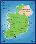
- Ireland |
E2
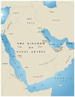
- The Kingdom of Saudi Arabia |
E3
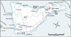
- Tenerife
|
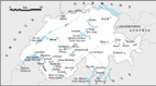
E4
- Switzerland
|
|
 |
 |
 |
 |
|
|
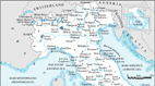
E5
- Northern Italy
|
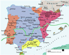
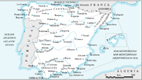
E6
- Spain
|
E7
- Germany
|
E8
- Rhodes and Cyprus
|
|
|
|
|
|
|
|
 |
 |
 |
 |
|
|
E9
- Madeira
|
E10
-The Baleares
|
E11
- Countries of the World
|
E12
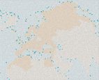
- Reviewed area
|
As it used to be (a few scanned images of maps that I have compiled and drawn to order by traditional means): top, previous
 |
 |
 |
 |
|
F1
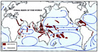
- Coral reefs of the World |
F2
- Kuwait |
F3
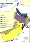
- The Geological Formation of Oman |
F4
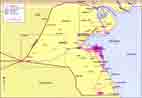
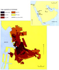
- The Growth of Jeddah |
 |
 |
 |
 |
|
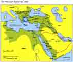
F5
- The Ottoman Empire, 1800
|
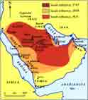
F6-
The Growth of the first Saudi State
|
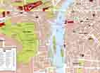
F7
-
Central Prague
|
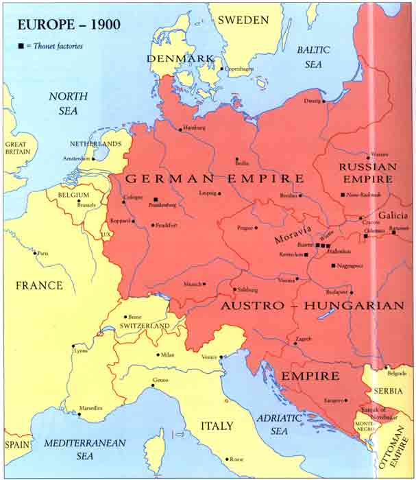
F8-
Thonet
factories, 1900
|
 |
|||
|
F9
-
German Expansion 1936 - August 1939
|
|
My very first printed map:
 |
|||
|
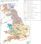
G1 - Baroque in Hungary (1606) |